1.09.13
Trip up to Yosemtie Valley to see the snow... and fight the crowds for a mere hour and a half before seeking refuge at Happy Burger in Mariposa. The setting sun provided great light on the metamorphic foothills around Hornitos Road.


11.4.12
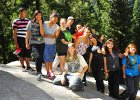
Photos from the Robert Fore Excellence in Science Teaching conference in Wawona. (AND A BEAR!


10.22.12
Two updates from WildLink can be found on the WildLink Page (using the link above).

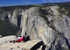 Sentinel Dome & Taft Point Exploration Hike
 Kings Canyon National Park Expedition | Sept 23-28, 2012
9.18.12
Congrats to my "little" cousin Noelani and her man Bennett on their awesome wedding. Because they have made me feel old, I am holding off on a wedding gift until I once again feel young (likely very soon). In the meantime I've published their wedding photos below. I'm no people-person photographer, but there are several nice shots here and there.

9.9.12
| NAGT FWS 2012 Saddlebag Lake Downloads |  |
||
|---|---|---|---|
| Google Earth Waypoints & Tracks: | (25kb) | ||
| Field Guide (COLOR!) | (5.3mb) | ||
| Small Photo Journal | Photos | ||
I had the pleasure and privilege of guiding a group of adventurous and college geoscience professors and students through the 20 Lakes Basin. I appreciated their patience with me since it was the first field trip for professionals that I had ever led. Despite a few changes to the timing of the trip stops (and outright eliminating several stops) the group was enthusiastic and got to experience the convoluted geologic history of the area. To learn more about the geology and climatology of the area, please download our full-color field guide.
8.15.12


 Steve, Brad and I had the pleasure summiting Mt. Whitney (14,505') on an overnight backpacking trip, braving a night of rain and 22 round-trip miles to do so. The experience was intense, and the hike was a butt-kicker. 6,000' of elevation gain in just over 11 miles makes the trek hard for even the most athletic folks. The views along the hike were great and the Perseids would have been spectacular had clouds not blanketed the sky at the peak of the meteor showers. Plus there was tons of geoscience to be seen, including the 83 Ma Whitney Granodiorite, air pollution in the Central Valley, thunderstorms and the effects of human waste on the lakes and streams in the area. Whitney also has the distinction of being the tallest mountain in the lower 48 states and is only 85 miles away from Death Valley - the lowest elevation in the western hemisphere at 282' below sea level. Have fun looking at our trip.
7.12.12


 Join me, Steve and Brian on an epic and breathtaking 34-mile journey through the Emigrant Wilderness in the Stanislaus National Forest. Day 1 – Leavitt Lake to High Emigrant Lake over the volcanics of the Relief Peak Formation. Day 2 – High Emigrant Lake to Frasier Lakes, with perhaps the most stunning camp view you'll ever see. Day 3 – Frasier Lakes to Gem Lake via Wood Lake. Day 4 – Gem Lake to Crabtree Trailhead. I've annotated every photo so please read the photo journal for a full description. I hope you enjoy the trip as much as we did. GO TO www.mrhollister.com/hikes to find all the specifics of the hike.
7.9.12 - Just returned from an epic ~34 mile backpacking trip that transected the Emigrant Wilderness from Leavitt Lake to Crabtree Trailhead. I have a bit of a stomach bug, but am working through it to organize the amazing photos from the trip. Stay tuned!
7.4.12


 Laura and I got to experience an out of this world adventure of a lifetime without really going all that far. Back in March we ran across a flier via Twitter that was promoting an Earth and Space Science Teacher Leadership academy funded by NASA and the AGI and hosted by Arizona State University. We really wanted to go, but the selection process was intense with requirements for letters of recommendation, resumes and letter of intent. We had no idea if we'd get selected and waited many weeks to hear of our fate. Luckily we were good enough to get in and got WAY more than we bargained for (we were the only Californians selected). Day 1 – Place-Based teaching methodologies for Earth Science systems. Day 2 – Meteorites (we got to hold the oldest fragments of rock in our solar system!!) Day 3 – Mars! Day 4 – Lunar Day (including ORGINAL photo prints from the astronauts of Apollo 16!!) Day 5 – Astrobiology. Laura and I were a bit depressed after arriving back in Turlock. Our scientific senses had been so stimulated for such a prolonged time we didn't know what to do with ourselves. We are very grateful to the folks who made this academy a success and were very proud that we got to represent California.
6.10.12


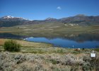
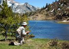 Photos from out three-day sojourn to Convict Lake. My dad had won a free pontoon boat rental at the lake and we decided to spend the nights there in the lovely and quaint Convict Lake Resort cabins. The fishing on the lake sucked, but Convict Creek was very productive as my dad caught a 21" brown trout. On the trip home we checked out Hot Creek Geologic Area, went for a hike to Fantail Lake near Tioga Pass and even squeezed-in dinner at the Whoa Nelly Deli. It was a great trip! One important note: all the photos were taken using an old sony point and shoot since my D700 was in for cleaning. For more information on the geology of Hot Creek please see the following information from the USGS.
6.5.12
Lest you think I forgot about the transit of Venus, fret not. Here are the photos.
5.30.12
 Kirman Lake, nestled on the outskirts of the Toiyabe National Forest near the junction of highways 108 & 395 is home to some very large trophy brook and Lahontan cutthroat trout. Because the fishery is special, it is managed with special regulations. Only artificial lures may be used and no more than two fish with a minimum size of 16in may be kept. The lake is somewhat secluded but merely requires an easy three mile hike or mountain bike on good dirt road to reach the land of sage, reeds and large fish. My dad and I made the hike in an hour and I was well rewarded by catching seven fish. I landed four fat 14-15in brookies and three 16-18in cutthroat while fishing from about 10:30am through 5:30pm. My dad on the other hand wasn't so lucky as he was skunked! We both used Z-Rays and variations of Panther Martins. The lake is very shallow and reedy along the shore, making a trailboat or float tube a must for effective fishing. Please practice catch and release. On a side note, these photos were taken with a small Sony camera while my D700 is in for cleaning.5.30.12
5.20.12

 The annular eclipse of 2012 was pretty spectacular, and here are the photos to prove it. We were just south of the "sweet-spot" latitude and thus didn't get to see the complete ring of fire. But what we did witness was awesome!
5.2.12

 Twenty-two intrepid WildLink explorers braved a long drive to experience the solitude and wonderment at Kehoe Beach, Point Reyes National Seashore. We perfectly timed a low-tide and thus had plenty to explore. Several students picked-up a great deal of flotsam including fishing nets and even a few plastic fishing floats with Japanese writing. By all accounts, this material pre-dates the tsunami debris. After spending nearly two hours at the beach we headed back to the Pt Reyes visitor center to have our usual Costco catered lunch. With full bellies we made the 34-mile windy drive down HWY 1 to Muir Woods National Monument where we were monumentally disappointed. Apparently everyone in the Bay Area decided to take advantage of a nice day and turned the Muir Woods Road into a three-mile long parking lot. Since there was ZERO chance of finding parking we begrudgingly decided to visit Muir Beach instead to finish-off the day and to see where Redwood Creek enters the Pacific Ocean. I think everyone had a great time except for the doggone traffic coming home!
4.15.12

 With our spring vacation quickly coming to an end, Laura, Ellen (our guest teacher from Germany), my folks and my Auntie Dianne all decided to get out and see some wildflowers. Thanks to several reports from friends who live El Portal and Foresta, we decided to focus our efforts along the South Fork Merced River Canyon via the Hites Cove trail. We were not disappointed. The abundance and variations of flowers was truly stunning, especially since our rains have come so late in the season this year. The poppies would have been the show-stopper, but due to cloudy skies they never really opened-up to their full glory. Needless to say the display should be good for another week or two, as the bloom seemed to be just getting started. We capped-the day off by swinging through Yosemite Valley. Great day!
4.13.12
 Here are the photos from our trip to Death Valley with Ellen! We had an action-packed four days with perfect weather!
2.26.12

 Phew!! I’ve finally weeded-out the worst photos and have decided to share with you a mere 224 pictures from our most recent trip to Death Valley with MJC. We had a HUGE crew this year (38, to be exact) yet somehow managed to be very efficient and scholarly. I dare say that with new a new stop to Bonnie Claire Playa, great weather and a little extra time to ourselves in the evening at Furnace Creek camp, this trip was one of the best with which we’ve been associated.
1.30.12


 Twenty-Four WildLinkers had the best day EVER thanks to the volunteer driving of Mr. Hoobyar, Mr. Julien, Mrs. Rowan, Old Man Hollister and Brett. The perfect January day in Yosemite Valley. 45 degrees, sunny, a smidgen of left-over snow, flowing falls, ice skating and to top it all off - HAPPY BURGER!
1.21.12


|Google Earth View|
Twenty-five WildLink club members (and their volunteer drivers) braved a blustery and showery Saturday morning for the privilege of planting the first several hundred plants in the last phase of habitat restoration on the San Joaquin River National Wildlife refuge near Grayson, CA. Thanks to the great prep work of the River Partners and Yosemite WildLink program director/coordinator, our club helped to put a small dent in the 549 acres yet to be planted in the reclaimed farmland that is within the floodplain of the mighty San Joaquin River. Volunteers planted a variety of plant species including, valley oak, blackberry & alder. Our plants should take root easily and mimic a wild area within five years. Our WildLinkers should be very proud of their hard work. It’s nice to know we’ll forever be a part of the San Joaquin river’s ongoing recovery!
2011 UPDATES CLICK HERE
2009-2010 UPDATES CLICK HERE