11.26.2011
Hit & Run Accident in front of our house:


This hit & run accident occurred Thanksgiving Night at about 7:52pm on ROSE and MARSHALL streets in Turlock. A blue/silver Toyota Camry with three occupants was heading northboundon Rose St at a high rate of speed, running the stop sign at Marshall. Upon entering the intersection, the Camry forcefully impacted an eastbound red chevy S-10 with one occupant on the passenger side door. The resulting force caused the pickup to roll at least once and come to a rest on the lawn 1205 E Marshall. The three Camry passengers immediately fled the scene while the dirver of the S-10 miraculously exited the driver's side door shaken, but with no outward signs of injuries. A large quantity of beer cans were observed in the front passenger seat of the Camry and several cans were strewn into the intersection. If anyone has information on the suspected driver or passengers of the Camry, please contact the Turlock Police Department.
09.17.2011
BURST ROCK RIDGE


The Turlock & Pitman High WildLink Clubs started the 2011-2012 school hiking season right. Sixteen club members, Mr & Mrs H and Mr Campbell took on one of the best “bang for your buck” trails: Burst Rock in the Emigrant Wilderness. Despite the fact that it was opening day of deer-hunting season and the trailhead parking was packed, we ran across very few folks on the trail. Once at Burst Rock, we headed up Burst Rock Ridge off-trail on the hard granite. Upon gaining the summit (9,200’) of the ridge we were treated to expansive 360 degree views, seeing peaks as far away as 25 miles. The surrounding meadows were still very wet and green, unusual for this time of year. There were even a few patches of ice that were still somewhat snow-like… enough so to make a snowball, anyway. Overall a great day! (Oh yeah… we spread our group out so not to heavily impact the wilderness).
9.5.11
LEAVITT CREEK


Why drive to a small creek, on a rough 4x4 road that was packed with yahoos on a Labor Day weekend? Becuase if you stop half-way up the road, get off your butt and walk, you'll have several square miles to yourself. I really wanted to try and catch a photo of secret "waterwheel"-type water fall, but the receding snowpack had lessened the flow of Leavitt Creek enough to make only a pretty cascade without the extra blast of jumping water. What to do as a back-up? Fish, fish, take photos, fish and find a tremendous surprise nearby. Take a peek at this photo journal to see the treasure Laura found.
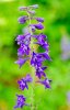
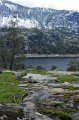
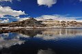
8.28.11
BLUE CANYON LAKE

![]()
Wanting to beat the forecast valley heat, but not wanting to stray too far away from home, my mom, dad, Laura and myself decided to give Blue Canyon Lake another shot after first hiking the area in 2005. We thought we knew what we were getting into with the steep, short, high elevation trail leading to a glacial cirque that has spots of loose tread. It turns out that we grossly underestimated the beauty of the wildflower bloom. The proliferation of flowers contrasted against diffused 70% cloudy skies made for a day to remember. The perfume from the various mint, lupine and wild onions combined with high elevation made for sensory overload. The only downer on the hike was a huge, fat spec of dust on my camera’s sensor that I have photoshopped out of most photos. Disaster was averted and sensor cleaned today!
As far as the geology in the area, here’s the brief version: Granites intrude 80+ million years ago. Surface weathering exposes rocks by 11 million years ago. Little Walker caldera spews huge amounts of ash, mudflows 10ma recovering exposed granites. Glaciation over the past million years re-exposed the granites and carved out common glacial erosional features in remaining lava flows on high peaks. Enjoy the photo journal of one of the best, prettiest hikes in the Emigrant Wilderness.
8.14.11
RAINBOW LAKE BACKPACK

 Rainbow_Lake_Backpack Google Earth Link
Two more updates. First a great backpacking trip through the Ansel Adams Wilderness to Lady and Rainbow Lakes.
WYOMING AND NEVADA

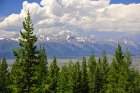
Here's the our trip to Wyoming to see friends and search for ammonite fossils in Nevada on the way back. Give the phot journals a look!
7.26.11
SECRET & ROOSEVELT LAKES
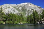

Two updates here. First is a photo journal from our hike to Roosevelt and Secret Lakes near Sonora Pass where we were skunked fishing but got to see some amazing sights (above).

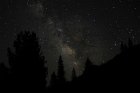
Secondly, we finished a great geology trip with Noah Hughes of MJC to the High Sierra. Staying at Baker Station for two nights along HWY 108 was luxurious! I also got some nice shots of the Milky Way while we were there.
7.12.11


I've recently posted two hikes from the past month. One to Bell Meadow near Pinecrest, the other to Lake Eleanor in western Yosemite that we completed in early June before the geology field trip. You can get the google earth files and topos at right...
7.6.11


The photos from the 2011 version of MJC’s Pacific Northwest Geology and Anthropology are finally posted with as many descriptions as I could squeeze into 700 photos (culled from 1500). The trip highlight this year was the amazing array of wildlife we got to see. Nine grizzlies, several bighorn sheep, a moose, a black bear, countless elks, deer, pronghorn and even a stray badger at Topaz Mountain! Oh yeah, there was a dog-bear in Glacier National Park, but you’ll just have to read Geotripper’s blog to see what that was all about. I’m trying a new photo album format so tell me what you think on Twitter @phreatic . Enjoy!
5.25.11


Yeah! I finally whittled-down (trust me I, did) the bazillion photos from our trip to Hawaii last month. I have added some juicy tidbits of info in the captioning. With the Big Island being twice the size of the rest of the islands combined, we ended-up driving nearly 1000 miles in our rented jeep probing for our next trip to the island in the future. Regardless of the driving, we had a relaxing, revitalizing vacation. There are a ton of photos, but I think you might find them interesting.
04.09.11

 Thirteen WildLink club members braved the unseasonably cool April temperatures to partake in a wonderful hike at Hetch Hetchy Reservoir in Yosemite National Park. On the road into Hetch Hetchy we stopped in a snowy meadow to play in some snow and observe hoarfrost. Once we arrived at Hetch Hetchy the students learned about the history/impact of the O’shuagnessy Dam and the water/electrical resource it supplies to San Francisco. We then set out for the base of Wapama Falls which was putting on a spectacular display thanks to the large snowpack. Unfortunately we couldn’t view the full extent of the falls since the bridge across the falls had been wiped-out in an October storm. The weather gods made up for our bad view with a brief shower of snowflakes and snow pellets that made the hike seem as if it took place within a giant snow globe. Overall, a fantastic day!
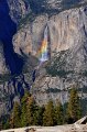
04.03.11

 Laura and I decided to go for a drive into the foothills looking for signs of wildflowers. Although the hills were tremendously green, the wildflowers appear to be 7-10 days away from really going bonkers. There were patches here and there near Coulterville, but nothing like the crescendo that I imagine will take place within the next several weeks. Oh, we also detoured into Yosemite Valley to see the waterfalls already bombing off the cliffs. If there was a low spot on the lip of a cliff, there was water running off it! Our trip was capped with a stellar sunset along the Tuolumne River near La Grange.
03.27.11

 Since Laura was busy teaching Yoga, and my dad was competing in his first track meet for quite sometime, my mom and I decided to head up to Twain Harte and see just how much snow our cabin had accumulated in the huge series of late-March storms. To our surprise nearly 3ft had piled-up, and teh plowed roads blocked access to our parking area in front of the cabin. Amazing! To finish the day we drove home via Marshes Flat Road to see if any wildflowers were out and about. They were not, but Hatch Creek was flowing nicely.
02.26.11

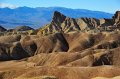
The photos from the 2011 version of MJC's annual geology field study in Death Valley are now posted. The trip started ominously, but like good heroes in a sci-fi drama, we always seemed to avert disaster while incurring some minor setbacks. We still got to see a majority of the sites that had been planned and best of all we didn’t get rained on for more than five minutes. New for this year were several attempts at night photography that I think came out quite nicely for my first try. I’ve also added quite a few geologic descriptors to the photos in hopes that you may learn something about the amazing park that boasts the lowest place in the U.S. and can be among the hottest and driest places in the world.
02.23.11
Click Here for seafloor Google Map exercise.
Click Here
To try the exercise in Google EARTH click here or here.
01.28.11
Google Earth Plate Tectonic Map Activity! CLICKE HERE!!!
01.06.11
Hey you! Yeah you... geoscience student! Click HERE to open the Virtual Siesmometer Lab. Don't forget, you can simulate the SoCal, Japan & Mexico EQ's for EXTRA CREDIT!
01.01.11

 After waking to an amazingly clear morning after a small series of storms, Mrs. H and I decided to rent some snowshoes from Sunsports and head to Yosemite Valley for the day. We had been cooped-up hosting and entertaining folks most of the holiday vacation and just had to get out of town. The trip to the park was detoured by a small rockfall near the HWY 140 entrance which shut down that road for 36 hours (article and photo here). Mrs. H had a premonition that the road would be treacherous with all the rain we'd experienced, so we actually went into the park via HWY 120 – a much longer and slower drive due to snow. Once we finally got to the Valley, we ended up hiking along the Ahwiyah Point trail on the opposite side of the Mirror Lake road but only got to the "lake" before we got distracted with photos and the desire to get to higher ground for some sunset shots. Here's what we came away with! (To see remnants of the Ahwiyah Point Rock Fall from 2008 CLICK HERE
12.29.10
 Mrs. H and I headed off for a quick day-trip to the brand new Fossil Discovery Center of Madera County in lovely Fairmead, CA. The museum was built in collaboration with the San Joaquin Paleontological Society and Madera County to permanently display the rich Irviningtonian Stage fossils first discovered in fresh excavation cells at the Fairmead landfill in 1993. Paleontologists originally thought the recovery of fossils on site would take two weeks but kept discovering more and more fossils as new cells were excavated. Through an agreement with the county, museum and landfill managers, paleontologists now walk behind excavators when new cells are being dug and flag fossils for recovery. The rich fossil assemblage that dates somewhere between 400,000 and 800,000 years old has yielded fifteen different species of large mammals ranging from horses to short-faced bears. It’s quite an exercise to imagine these beasts roaming around our backyard during the last ice-ages when the climate was much more savannah-like. The fossils are not as well-preserved as their cousins in La Brea due to the fact that most fossils were deposited in flood debris from the ancient Chowchilla River. The museum is off to a great start, and I was quite surprised to see so many people attending. Within three years I can envision this museum being one of the top three in the central valley. Admission is $8 for adults and $4 for students. Currently the tours last about 25 minutes and we were done perusing the museum in a little over an hour. A great day trip if time is short! DIRECTIONS HERE
Looking for the FINALS COUNTDOWN VIDEO? Here it is.
12.13.10

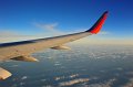
Mrs H and I had a great trip to Mississippi State University for my Master of Science in Geosciences graduation ceremony. Two straight years of hard work paid-off with a 4.0 GPA and membership to the Phi Kappa Phi honors society. Not to mention that my high school students will now get a better education from my enhanced knowledge. The photos show some of my grad pics, but mostly showcase the flight from Oakland to Houston to Jackson, MS. Have fun!
11.11.10

 Seventeen WildLink club members took advantage of our Veteran's Day by enjoying the lands our military men and women fought so hard to keep free. The club settled on hiking to Cleo's Bath above Pinecrest Lake since it offered the perfect blend of hiking, adventure and of course, snow play. The fall colors of the oaks around the lake were in full display, adding to the already gorgeous scenery of this perfect day. Everyone on the trip worked hard to make sure everyone made it up safely to the top of Cleo's Bath using tremendous amounts of good spirit and teamwork. A big thanks to Daisy's mom and unlce for driving a van, as well as to the Senior Mr & Mrs H for driving a truck with several club members. Without them not nearly as many of us could have had fun! Click the photos to see the trip, or click HERE to see the all new WildLink Club webpage
11.7.10
 As per our usual, Mrs. H and I went to the extreme high country of Yosemite this weekend before the passes were closed for the season due to snow. We decided to do our favorite November hike to Gaylor Lake on the extreme eastern edge of Yosemite. The trail begins at the east Yosemite entrance station at about 9900' and then climbs to just over 10,500' in under a mile. The cool temperatures, passing snow showers and lack of oxygen made this a very rewarding hike for the end of the season.
11.2.10
 Mrs. H and I had decided to take advantage of a wonderfully clear Halloween day by taking a very brief day-trip to Yosemite. Recent rains on Friday and Saturday (with snow in the high country) brought the waterfalls in the park back to life. Even better was the fact that clouds cleared out after the weekend weather front passed, leaving a tremendously clear atmosphere. To take advantage of the views from a high vantage point we decided to return once again to Sentinel Dome and see what we could see and still get home in time to see the Giants win Game 4 of the World Series. What we actually saw was amazing, topped by Yosemite Fall’s peacock impression which you can see towards the tail end of the photos.
TO SEE ALL PREVIOUS 2009-2010 UPDATES CLICK HERE