12.29.10
 Mrs. H and I headed off for a quick day-trip to the brand new Fossil Discovery Center of Madera County in lovely Fairmead, CA. The museum was built in collaboration with the San Joaquin Paleontological Society and Madera County to permanently display the rich Irviningtonian Stage fossils first discovered in fresh excavation cells at the Fairmead landfill in 1993. Paleontologists originally thought the recovery of fossils on site would take two weeks but kept discovering more and more fossils as new cells were excavated. Through an agreement with the county, museum and landfill managers, paleontologists now walk behind excavators when new cells are being dug and flag fossils for recovery. The rich fossil assemblage that dates somewhere between 400,000 and 800,000 years old has yielded fifteen different species of large mammals ranging from horses to short-faced bears. It’s quite an exercise to imagine these beasts roaming around our backyard during the last ice-ages when the climate was much more savannah-like. The fossils are not as well-preserved as their cousins in La Brea due to the fact that most fossils were deposited in flood debris from the ancient Chowchilla River. The museum is off to a great start, and I was quite surprised to see so many people attending. Within three years I can envision this museum being one of the top three in the central valley. Admission is $8 for adults and $4 for students. Currently the tours last about 25 minutes and we were done perusing the museum in a little over an hour. A great day trip if time is short!
Looking for the FINALS COUNTDOWN VIDEO? Here it is.
12.13.10

Mrs H and I had a great trip to Mississippi State University for my Master of Science in Geosciences graduation ceremony. Two straight years of hard work paid-off with a 4.0 GPA and membership to the Phi Kappa Phi honors society. Not to mention that my high school students will now get a better education from my enhanced knowledge. The photos show some of my grad pics, but mostly showcase the flight from Oakland to Houston to Jackson, MS. Have fun!
11.11.10

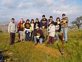
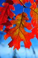 Seventeen WildLink club members took advantage of our Veteran's Day by enjoying the lands our military men and women fought so hard to keep free. The club settled on hiking to Cleo's Bath above Pinecrest Lake since it offered the perfect blend of hiking, adventure and of course, snow play. The fall colors of the oaks around the lake were in full display, adding to the already gorgeous scenery of this perfect day. Everyone on the trip worked hard to make sure everyone made it up safely to the top of Cleo's Bath using tremendous amounts of good spirit and teamwork. A big thanks to Daisy's mom and unlce for driving a van, as well as to the Senior Mr & Mrs H for driving a truck with several club members. Without them not nearly as many of us could have had fun! Click the photos to see the trip, or click HERE to see the all new WildLink Club webpage
11.7.10
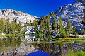
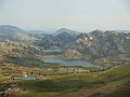
 As per our usual, Mrs. H and I went to the extreme high country of Yosemite this weekend before the passes were closed for the season due to snow. We decided to do our favorite November hike to Gaylor Lake on the extreme eastern edge of Yosemite. The trail begins at the east Yosemite entrance station at about 9900' and then climbs to just over 10,500' in under a mile. The cool temperatures, passing snow showers and lack of oxygen made this a very rewarding hike for the end of the season.
11.2.10
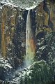
 Mrs. H and I had decided to take advantage of a wonderfully clear Halloween day by taking a very brief day-trip to Yosemite. Recent rains on Friday and Saturday (with snow in the high country) brought the waterfalls in the park back to life. Even better was the fact that clouds cleared out after the weekend weather front passed, leaving a tremendously clear atmosphere. To take advantage of the views from a high vantage point we decided to return once again to Sentinel Dome and see what we could see and still get home in time to see the Giants win Game 4 of the World Series. What we actually saw was amazing, topped by Yosemite Fall’s peacock impression which you can see towards the tail end of the photos.
10.17.10
It was 21 years ago this evening that the Loma Prieta EQ struck Northern California. And with that memory out of the way, feel free to have a looksie at some amazing photos from the past two weekends that I was able to capture on various geologic field studies.
 |
 |
NAGT Fall 2010 - Kings Canyon |
Central Mother Lode - MJC |
9.24.10
This weekend is a FREE ENTRANCE weekend at Yosemite National Park! Take advantage of this deal (normally $20) to see the many minerals and rocks we'll be discussing in class over the next two weeks. You should also hit-up the California State Mining & Mineral Museum in Mariposa along the way for 20% extra credit on a test. If you do make it to Yosemite, I'd suggest heading to the Tuolumne Meadows area for the most peace and quiet after visiting the valley floor. For the best views with minimal effort, Glacier Point is the place to go. Sunset is still after 6:50pm, so there's lots of dayligt if you get up early enough! Be sure to print out the extra cedit worksheet and also Mr H's book that describes lots of cool geoscience on the way to Yosemite!
| Map to Mineral Museum | Map to Yosemite |
Mineral Museum Exta Credit Worksheet |
| Photos of Museum
| Mr H's Geoscience Field Guide (10mb PDF)|
9.23.10
 Here are the latest and greatest photos from this year's WildLink Expedition. The actual WildLink Club page on MrHollister.com will be getting some much needed attention in the near future, but in the meantime you can find all the other expedtions from years past in the "Hikes & Adventures" section of the website.
9.1.10
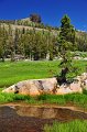
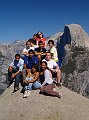
 Looking for a trailhead in Yosemite that is away from crowds during the Labor Day weekend isn’t as hard as one might expect. One just has to be willing to drive a little further and be able to utilize basic topographic map skills to find a doable day hike that not many others know about. Chain Lakes is just such a hike located in the extreme south-eastern portion of Yosemite. Laura, my parents and myself took a gamble on making a longer drive than normal from Turlock to the Quartz Mountain Trailhead near Chiquito Lake on USFS Road 10. The forest road (Sky Ranch Road) out of Oakhurst is windy and full of potholes in the early section, but smoothes out nicely on the gravel and dirt portions. But 25 miles of 15-20mph road takes a while to finish, even in a Subaru. The trail to Chain Lakes itself gains a tad over 1300’ in 5.7 miles to the Upper Chain Lake and gets comparatively light use compared to most trailheads in the park. The climb is fairly gradual over variably dusty, sandy and rocky trail, but there are several instances of climbing that are steeper than others. Luckily the trail is shaded nearly the entire which allows ample shady spots to catch one’s breath. The lakes themselves are gorgeous and each contains a great fishery. Lower Chain has amazing rainbows to 14”, the Middle Chain has a mix of brookies and ‘bows to 16-18”, while the Upper Chain is all brookie all the time, with the biggest one I caught near 11”. The hike is a long one for a day hike, as we left the trailhead at noon and returned to the car guided by the last bit of alpenglow at 7:50pm. It’s a rewarding hike, but even better in October when NO ONE is around.
8.11.10
 |
 |
Parker Lake Mono Craters |
Spuller Lake |
Description of Spuller & Parker Lake Hikes to come. Photos of Spuller Laker HERE
8.2.10
 |
 |
 |
 |
 |
| House Boat | Taylor & Ward Creek (Tahoe) | Cooper Meadow | Virgina Lakes | Bodie |
Now that I’ve been allowed to come back to reality after finishing my MS in Geoscience (see previous entry), I’ve been able to get out and about and experience with my wife and family the many places within the Sierras that I had neglected for nearly two years. With so much lost time to make up for, we were able to visit several places within the last week that are noteworthy. First, we spent some time in Twain Harte and hiked near the Virginia Lakes, Cooper Meadow and the old ghost town of Bodie (although there were several hundred tourists there). From the cabin we headed down to Don Pedro Reservoir for some houseboat and Jet Ski fun with many of our friends. So enjoy the photos, there are a few great ones from each trip.
7.27.10


Well, hallelujah and praise the geology gods. After being a hermit for more than a month furiously typing and researching and typing and researching and typing and putting in a photo and typing and typing, I AM FINALLY DONE!!! Whoo Hoo! And what do I have to show for it? A 105 page epic field guide to Central California and Western Nevada. You can download the field guide here if you want to see how it looks.
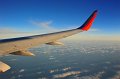
In the bigger picture, I was finally able to upload my photos from my Western Washington MSU Capstone course that occurred from July 8- 17th. It was quite a trip that ranged from Seattle south to Mt St Helens and Rainier, northwest to Olympic National Park and east to North Cascades National Park and the Channeled Scablands. You view all the photos by clicking the thumbnails above! And to all the TIG-er’s, I know I’ve misspelled names and haven’t narrated days 7 or 8 yet. I’ll get to it when I come back from a little vacation. Enjoy!
6.27.10
Phew! Only seven more days until I leave for my final course in my Master of Geoscience courses. I've been working very hard to put togethere a seven-day geoscience field guide for Central California & Nevada, and have to have that done before I head up to study the geoscience of Western Washington. In the meantime, I finally posted the photos (177 of them) from our Wyoming trip and yesterday's hike to Roosevelt Lake in the Hoover Wilderness. Enjoy!
 Roosevelt Lake Hike
  Nevada/Idaho/Wyoming/Idaho/Montana/Idaho/Washington/Oregon Trip.
5.31.10
 Alex, Aric, Dave, Steve, myself and even Web made it up to Cherry Lake for a weekend of dude-camping before all the new babies arrive later this year. We had fun playing cornhole at the camp and hiking along Lake Eleanor’s shores for some relaxing fishing and sun-bathing. Cherry Valley campground was a very pleasant campground, with the sites well-spaced for a bit of privacy. On Sunday, we all ventured to the north shore of Eleanor to take-in the splendor of the raging Kibbie Creek Cascades. It was an amazing weekend and I’m pretty sure everyone had fun.
5.16.10
 What's it like to have nearly all your closest friends together in on spot for the night? How about completely hillarious, especially with so many expectant mothers. Must be something in the water. My eyes are still recovering from the Balderdash laughter/crying fiasco.
5.8.10
 Mrs. H and myslef took my folks up to the Calaveras Big Trees today for Mother's Day. A cold front pushed on through the area amking for a clod 41 degree high in the park. After our journey through the North Grove we headed down to the South Grove, but light hail and snow convinced us to make the rest of the afternoon an auto-tour. We took the Subaru up to Alpine Lake where there was still seven to eight feet of snow on the ground with several new incehs accumulating while we were there. A great day!
4.26.10
Just thought I'd mention that I've finished my last two classes for my Master's of Science in Geosciences. Three weeks left until my comprehensive finals, a few more things here and there this summer and I am finished! Woo Hoo!
4.17.10
 Four Turlock High WildLink Club members, along with four THS Ag students experienced a tremendously informative and exhilarating day filled with history, biology and geology at Los Banos Reservoir as part of the Path of the Padres interpretive hike. Ranger Richard was kind enough to guide us on the original trail used by Catholic Padres of the late 1700’s to navigate across the Diablo Range into the Central Valley . This trip was special because we were able to view many snakes, turkeys, turtles, and even several deer along with a huge variety of birds amongst the browning grasses and remnant wildflowers. The hike up "Optional Hill" also provided stunning views of Twin Peaks, most of the Diablo Range, and of course the smoggy Central Valley.
4.11.10
 Laura & I had the good fortune to spend three fine days in Yosemite with our German exchange teacher, Ellen along with fellow colleagues Julie & Jill. The large snowstorm from the previous Monday gave us plenty of snow on which to snowshoe near Crane Flat, but the warm temps allowed us to do so in T-shirts. Friday we took advantage of perfect weather once again as we admired the views at Hetch Hetchy. The water flowing off the valley's surrounding cliffs put on a dazzling spring show and I even managed to catch several brown trout in the reservoir. The wildflowers were still several weeks off from blooming, but carpets of red moss and green grasses went stunningly well with the blue sky. The drive back to Curry Village from Hetch Hetchy provided us two amazing bear sightings, several coyote sightings and a few deer as well. We closed the three days by visiting lower Chilnualna Falls where Ellen and I caught a glimpse of a bobcat near the foot trail's junction with the stock trail. One could not ask for a better three days in Yosemite! (NOTE: ALL GOOGLE EARTH & MAPS FILES CAN BE FOUND IN ALBUM PAGE)
4.05.10
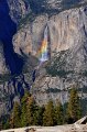
 Laura and I got to play tourguides for a day by showing Grandpa, Uncle David and his son, Kyle, the sights of Yosemite. We had planned on a bit more of an extensive trip, but 18" of fresh snow in the valley dictated that we go with the old tourist sights. Luckily for us, the fresh snow made the familiar look spectacular! Be sure to check out the amazing rainbow captured on Bridalveil Falls.
4.03.10

![]() Seeing Carrizo Plain National Monument in all of its rare spring-time glory had always been very high on my "to do" list. Ellen, our colleague and house-guest from Germany, was visiting once more and we really wanted to show her something special. Using my intuition as a guide (and a little internet research) I discovered that, indeed, the wildflowers were amazing at Carrizo. Thus Laura, myself, my mom and Ellen hopped into our Subaru Forester and made the long 200 mile drive from Turlock to see a once in a lifetime display. Lets just say that we were not disappointed with what we saw. The colors were amazing and made the long drive worth every minute. Enjoy the photos.
Seeing Carrizo Plain National Monument in all of its rare spring-time glory had always been very high on my "to do" list. Ellen, our colleague and house-guest from Germany, was visiting once more and we really wanted to show her something special. Using my intuition as a guide (and a little internet research) I discovered that, indeed, the wildflowers were amazing at Carrizo. Thus Laura, myself, my mom and Ellen hopped into our Subaru Forester and made the long 200 mile drive from Turlock to see a once in a lifetime display. Lets just say that we were not disappointed with what we saw. The colors were amazing and made the long drive worth every minute. Enjoy the photos.
3.15.10

![]() Fourteen WildLink club members had an amazing day visiting Point Reyes Nation Seashore. Our members got to experience many “firsts”: The first time any of them had stood on an actual fault, the first time many of them had seen the ocean, the first time many of them had seen elk, the first time any of them got to run their toes through the sand, etc, etc.
The day was nearly perfect. Temperatures were in the mid fifties with nearly 30mph winds. But our reward for braving the wind was a crystal-clear day in which we could literally see for miles.
Fourteen WildLink club members had an amazing day visiting Point Reyes Nation Seashore. Our members got to experience many “firsts”: The first time any of them had stood on an actual fault, the first time many of them had seen the ocean, the first time many of them had seen elk, the first time any of them got to run their toes through the sand, etc, etc.
The day was nearly perfect. Temperatures were in the mid fifties with nearly 30mph winds. But our reward for braving the wind was a crystal-clear day in which we could literally see for miles.
We started the day by entering the park from S.F. which required a beautiful drive across the Bay & Golden Gate Bridges. We then stopped for a fun geology jaunt along the San Andreas Fault and its rupture zone from the 1906 earthquake. We then headed out to Pierce Point Ranch on Tomales Point for a birds-eye view of the azure Pacific while on a four mile hike. Along the way we got lucky and spied some large Tule Elk very close to the trail, but no whales out in the sea.
The last stop of the day was at the amazing Kehoe Beach. Not only was there good geology (seeing the Laird Sandstone, the Monterey formation and Salinian granitics) but there were also tons of freshly deposited jelly fish! Not to mention the tide was out and everyone got to get their feet a bit wet and sandy. A great day was had by all and it would have been better if the doggone clock hadn’t lost an hour on Sunday morning! For more info on the Geology of Point Reyes, click here
2.22.10

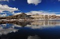
![]() A year off from the annual MJC Death Valley Field Study in 2009 meant that Laura and I were chomping at the bit to get back on the road during our 2010 Presidential Holidays. We volunteered as drivers for the trip again this year and since Laura is the 2009 NAGT Far West Teacher of the Year, she got to give a little spiel to the class on the hydrology of the park. In all, thirty four people and five vans left for the five-day trip Death Valley to see some of the most diverse (and oldest) geology in the state of California. Although recent storms closed most of the higher “vantage point” roads in the park we did get to see many rarities, such as the Amargosa River flowing and lots of water in Lake Manley. To see all of the trip stops, click the Google Earth File button to download & view. Enjoy!
A year off from the annual MJC Death Valley Field Study in 2009 meant that Laura and I were chomping at the bit to get back on the road during our 2010 Presidential Holidays. We volunteered as drivers for the trip again this year and since Laura is the 2009 NAGT Far West Teacher of the Year, she got to give a little spiel to the class on the hydrology of the park. In all, thirty four people and five vans left for the five-day trip Death Valley to see some of the most diverse (and oldest) geology in the state of California. Although recent storms closed most of the higher “vantage point” roads in the park we did get to see many rarities, such as the Amargosa River flowing and lots of water in Lake Manley. To see all of the trip stops, click the Google Earth File button to download & view. Enjoy!
1.16.10
 Laura, myself & my folks completed a nice, but strenuous hike down to Indian Creek and the Tuolumne river on Saturday before teh big storms hit. TO see the amazing photos and read more about the area, click on teh photo at left, or see the maps in the "Recent Hikes" section at right.
12.09.09
![]() Ten THS students, one PHS student and four Silva grandkids braved the foggy cold atop Pacheco Pass to help restore and create trails within Pacheco State Park. After five hours of work the group accomplished the following: 1. Repaired 130 yards of trail; 2. Created 155 yards of new trail; 3. Cemented six new metal sign posts; 4. Had a great time helping the park create a path that will be used for many generations of visitors. The park is quite beautiful this time of year and supports mountain biking as one of the main activities along its trails. This park should be a highly recommended destination for those looking to escape valley fog. One can enjoy a diversity of wildlife amongst the HUGE oak trees that dot the park in near solitude.
Ten THS students, one PHS student and four Silva grandkids braved the foggy cold atop Pacheco Pass to help restore and create trails within Pacheco State Park. After five hours of work the group accomplished the following: 1. Repaired 130 yards of trail; 2. Created 155 yards of new trail; 3. Cemented six new metal sign posts; 4. Had a great time helping the park create a path that will be used for many generations of visitors. The park is quite beautiful this time of year and supports mountain biking as one of the main activities along its trails. This park should be a highly recommended destination for those looking to escape valley fog. One can enjoy a diversity of wildlife amongst the HUGE oak trees that dot the park in near solitude.
11.17.09
 Twenty-two!! Well-behaved students got to visit the only private water bank in the United States on a lovely November Saturday. The students were first given an overview of the site and shown how the farm stores water in aquifers underground for safe keeping until dry years. Explained by the farm’s biologist, Jason Dean, the complexities of water banking & exchange were made clear & relevant to the students. The students were also made very aware of the positive environmental impacts provided by the farm. Students were then led by through a series of great team-building exercises by Dave before having a lovely lunch. After lunch the students learned the ins & outs of bird migration while playing “Migration Headache”. Due to time-constraints our original plans of clearing brush from the water bank ponds were delayed until our next visit to the bank, most likely in the spring when the water is flowing and birds are abundant. Thanks to Paul, Jason, Dave, Mr. Silva, Mr. Moser & Mrs. Hollister for helping to make this trip a great success!
11.03.09
 The October 2009 WildLink expedition saw a collaborative effort between Turlock & Pitman come to fruition. Ten great students were able to brave subzero wind-chill and 70mph gusts of wind on the first night of their trip to successfully complete their Tenaya Lake – Clouds Rest – Little Yosemite Valley – Curry Village trek. Seldom has there been an expedition that experienced frigid temps so low that soap, iodine & bottles of water to froze – IN THE TENT! Wednesday & Thursday warmed-up and allowed the participants to take a stab at Cloud’s rest from the difficult western approach. They made it and were rewarded with views and camaraderie to last a lifetime. Enjoy the many photos!
11.03.09
 Five fun-loving students gave up their Halloween to go hiking on a lovely afternoon in the Emigrant Wilderness. With temperatures reaching 62 at 9000ft and visibility going on for miles, our jaunt from Gianelli Cabin to Burst Rock & Powell Lake was a day-hike that truly pleased all. Enjoy the photos!
10.07.09
 I finally got around to posting the pics from the latest WildLink Expedition last weekend. You find them easily by clicking on the thumbnail at left or by going to the WildLink section of "Hikes & Adventures". This year's group got to stay in the newly reinforced tent cabins in Curry Village’s “Boys Town”. We ventured to Taft Point & Glacier Point on Sunday, conquered the Spider Caves with amazing teamwork on Monday and then packed the gear needed to go on the expedition Monday afternoon. There was also quite a sizeable rock fall (150 tons) that made a racket on Tuesday morning... all part of a life-time memory.
9.23.09
 Time flies when you're having fun. My family and I took a great hike to Kuna Lake in Yosemite on Saturday. You can read all about the journey by clicking on the thumbnail at left. It was a beautifully clear lake with great fishing & tremendous views. My classes will be starting the study of minerals tomorrow and the first WildLink expedition of the year will be departing on Monday! WooHoo!!!
8.21.09
 If you're one of my new students, congratulations on surviving the first week of school. Only 30-something more weeks to go! To add to the abbundance of hikes already on this site, our August 16th hike to the Hoover wilderness is now posted in teh recent hikes at left, and in my Wilderness Hikes section of the "Hikes & Adventures". It was a great hike!
8.15.09
 Well, it's almost time for school again! To get ready I headed off into the Emigrant Wilderness on an epic backpacking trip to High Emigrant Lake and Emigrant Meadow Lake. The views were amazing, the Perseid meteor showers were awesome, the fishing stupendous and to top it off I found a nice area of petrified wood & other fossils. Just click on the thumbnail below or go to the Hikes & Adventure Page to see where I went & what I saw!
7.26.09
 See Trip in Google Earth
I’ve just posted the photos from our great five day trip to Oregon that was made better by having our friends from Washington (Louie, Gina, Mia & James) and Turlock (Dave & Ericka) join us. We started the week by meeting in Lakeview, Oregon and staying the night there before heading out to the lava plateau’s outside of Plush, Or in search of Oregon Sunstones. Our success at the Spectrum Mine made it hard to leave for Crater Lake, but once we were there, the crystal-blue waters and great camp site made us forget all about the sunstones. We finished the trip with a great ride up the Rogue River on Jerry’s Rogue Jets with the legendary Tom Biggs as our pilot. It was the best jet boat trip that I can recall, having seen two bears, two river otters, scores of deer, six bald eagles, countless osprey and much more. Plus the 360’s done by Mr Biggs were quite fun too!
Enjoy the photos! CLICK
7.16.09
There are several big changes on this website that aren't very obvious, but I'd like your input on the changes. First, please vist my new California Wilderness Hiking Page and see how you like the new sortable columns. If it's a hit I'll slowly migrate all of my hiking pages to this format.
Secondly, I've published my photos for this year's Stanislaus County Fair in the Photos page and I hope you'll give them a peek.
Lastly, you should check out my most recent hike to Emma Lake near Bridgeport by clicking on it in the "Recent Hikes" area at right.
7.15.09
I had another letter to the editor published in the Modesto Bee today regarding aquifer depletion in the central valley. You can check out the letter here.
6.22.09
I know it's been a while since my last update, but I've been very busy doing a billion things, several of which included camping at Convict Lake and most recently hiking to Lower Relief Valley in the Emigrant Wilderness. You can find those photos at right in the "Recent Hikes" area. My entire hikes page is in the midst of a major upgrade that will allow users to sort hikes by eight different parameters. It's pretty cool, and I hope it becomes a more useful interface for users. I'm also updating the DIY (Do-it-yourself) page with the pergola I've built along with the new addition of a tomato cage that I invented.
For the time being you can find the Pergola & Tomato cage pages by clicking on the thumbnails below:


I've also been furiously studying for my Master's program and getting ready for midterms that are fast approaching. We have lots more hikes in the works this summer, so stay tuned!
5.26.09
Holy Smokes! This year went fast! Good luck to everyone on their finals.