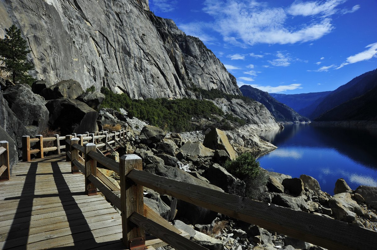
With Laura and Zephyr staying home with Laura’s friends I was itching to get out of the house and take advantage of the nutty drought. The lack of snow in the Sierras and unseasonably warm weather drew our attention to Hetch Hetchy once again. The 2014 version of the Hetch Hetchy hike was surreal. The temp was in the low 70’s. The Rim Fire laid waste to the Evergreen Road corridor and a good portion of the trail between the tunnel and Wapama Falls.. We saw a bear ambling along the road when it should have been sound asleep. We saw one measly patch of snow along the South Fork Tuolumne River. I caught a huge brown trout while standing near the old dam top and road. And I missed sharing the experience with Z and Laura. But my parents were good hiking company and the day was absolutely, horrifyingly perfect for March… to bad it was the middle of January.
1 Evergreen Road, the road to Hetch Hetchy wasn't looking so evergreen thanks to the Rim Fire.
2 Hazard trees along Evergreen Road had been chopped down after the Rim Fire
3 I thought this old oak stump and charred forest pretty much summed-up the dammage in the area from the Rim Fire.
4 The prize of the day was seeing this medium-sized black bear that was cinnamon in color. It's JANUARY and he/she was wandering in what appeared to be a sleepy daze.
5 My fixed 50mm was on my camera and I didn't want to miss the bear. Thus I didn't switch to a zoom.
6 One last crop of the bear just a few miles from the dam.
7 Condon point with a snippet of the O'Shaughnessy dam .
8 The water levels were down about 90 feet this day. Tueeulala Falls was dry as a bone (center of photo).
9 This is a better view of dry Tueeulala Falls and the trickle that is Wapama Falls. Note the burned trees on the talus below the falls.
10 My mom & dad check out the damn while I focused on the burn damage. The burn was a little less intense than what I had imagined for this area based on the hot spot satellite imagery I was looking at during the Rim Fire.
11 Dam.
12
13 We encountered our first burn damage after exiting the dam tunnel.
14 Believe it or not new life was springing from the ashes, even in the midst of a drought! I am not a botanist and cannot ID the type of plant in any reasonable time.
15
16 Quite amazing how some tree were burned while others in close proximity sustained no damage at all.
17 The lake levels were down (225,000,000 gallons per day will do that sort of thing) but the colors were amazing.
18 Even my favorite fern grotto was not spared the flames.
19 An admittedly crappy shot to document the fire in my favorite fern grotto.
20 The trail to Beehive Meadow and Laurel Lake were still closed. The trails march into the heart of the Rim Fire burn and I suspect much hazard mitigation still needs to be done.
21 Looking back towards Condon Point to document burn area.
22 Amazing that isolated trees on cliffs actually burned.
23 A mile or so into the trail put us into the heart of the worst burn area around Hetch Hetchy.
24 Not too many plants in this area survived the flames. But it was good to see the annual grasses sprouting in the midst of a drought.
25 My folks check out the majestic oak that was torched.
26 We pressed on through the burned manzanita.
27 This tree will make a great woodpecker home.
28 Various life springs from the ashes.
29 Life on the trail.
30 Egads, the burn was bad in this area.
31 Manzanita.
32
33 One of my favorite viewpoints on the trail only had moderate damage. In seasonably wet years, this area tends to be marshy and overflowing with the runoff of Tueeulala Falls.
34 My mom wanted me to take this photo. She called the area a fire creek since the channel was filled with ash and charcoal.
35 Wapama Falls
36 The switchbacks down to Wapama Falls pretty much delineated the eastern advance of the Rim Fire.
37 Wapama was a mere trickle.
38 It's hard to imagine several folks have been washed off these bridges and swept to their death during high run-off of Wapama Falls.
39 Another view of the trickle flowing over the 108Ma Granodiorite of Tueelala Falls.
40 The falls were sad, but their crystal-clear pools were not!
41 Shadow Selfie.
42 What color!
43 Small rock fall and splintered remains of its victims.
44 My folks look over the small rock fall damage. This tree was not burned. It was was smashed. Had to have been several months old based on dryness of leaves.
45
46 A view upcanyon. Le Conte Point on left with some very light snow in the background. This picture was taken on Jan 25. The last precip in the region fell on Dec 7th!
47 I found this charred manzanita to be interesting.
48 Alive? Dead? Beats me. It seemed that most of the Manzanita seemed to be okay.
49 My favorite geologic discovery of the day: A huge boulder of granite that exhibited signs of heat shattering. The rock got so hot that expanding minerals literally shattered and exploded flakes of rock off the boulder. I liked seeing the poison oak growing in the 'scree'.
50 Poison Oak rising from the ashes.
51 Yowzers, this was a hot burn.
52 I packed my camera and a made a beeline down to the exposed road from the original dam top. Time for some rocks and fish!
53
54
55 The Tonalite of Poopenaut Valley has been cross-cut quite nicely by veins of (what I think was plagioclase but can't remember) that were also rich in books of biotite about 1" wide. My 72mm camera lens cap for scale.
56 Another neat shot of the veins cross-cutting the tonalite.
57 Where the dam and rocks meet. Interesting buttressing.
58 I was too concerned with getting this bad boy back in the water to get a good photo. But my estimates out this brown trout at a minumum of 17" and 2+ lbs. It was a great fish. Had two other small guys pop-off near the shore after fun jumping.
59 And this was my final view of the day, from the old dam bridge.